Tactical NAV
- 3.9
- Rating
- 10.00K
- Installs
- $8.99
- Price

 Analysis by App-foxy
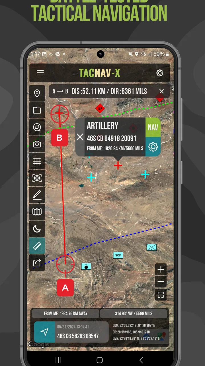
When I first opened Tactical NAV, I immediately understood that it was designed for a very specific kind of navigation rather than casual driving or sightseeing. This is a paid Maps & Navigation app from Jonathan J. Springer, built around military-style MGRS navigation. The focus is precision, reference-grid work, and deliberate movement through places where a normal street map may not be the most useful tool.
That narrow purpose is both its greatest strength and its biggest warning sign. If you need MGRS tools for training, field work, land navigation, emergency planning, or serious outdoor navigation, this app deserves a close look. If you simply want turn-by-turn directions to a restaurant, a familiar road map, or an easy travel companion, I would choose a conventional navigation app instead. Tactical NAV asks you to understand the coordinate system and work with it; it does not try to hide that complexity behind a consumer-friendly interface.
How the app handles readability and navigation
The most important accessibility question here is not whether the app looks like a modern lifestyle app. It is whether the information you need can be read and interpreted correctly while you are concentrating on a route, a map, or a coordinate. In my experience, the MGRS-centered design makes the app feel purposeful. It keeps attention on location data instead of surrounding the screen with travel recommendations, advertisements, or unrelated map content.
You May Also Like

 Blood Strike: 2.5 Anniversary
Blood Strike’s Loadouts Turn Every Drop Into a Tactical Gamble
A close look at Blood Strike’s custom loadouts: how fast access to signature weapons reshapes its battle royale rhythm, rewards preparation, and narrows the gap between fights.

 Pandora - Music & Podcasts
Pandora’s Music Is Easy to Start, but Harder to Recover
Pandora’s strength is its low-effort path from a seed to a station. Its weak spot is how much confidence it asks you to place in connection, setup, and quiet recovery.

 8 Ball Pool
 Is Built on Rivalries, Rematches, and Routine
A close look at the rivalries, rematches, shared routines, and unanswered safety questions that turn a quick pool match into a persistent mobile community.

 Samsung Music
’s Quiet Strength Is Playing What You Already Own
Its reach comes less from spectacle than from dependable access to a personal library. That simplicity is both the app’s strongest retention engine and its ceiling.

 AccuWeather: Weather Radar
AccuWeather Review: A Quick, Clear Forecast for Everyday Decisions
For everyday plans, the best forecast is the one you can understand quickly. AccuWeather makes rain timing, radar, and local conditions easy to act on, with a few trade-offs.

 Hill Climb Racing
Why Hill Climb Racing Still Turns Crashes Into One More Run
A tiny car, a bumpy hill and one more upgrade: Hill Climb Racing keeps resurfacing because its simple chaos makes every near-miss feel personal.
More From Our News Desk
View All News


That focus can help users who prefer structured information. A person who thinks comfortably in grid references may find the display easier to trust than a standard map filled with roads, labels, business markers, and visual clutter. The app’s value comes from turning a precise position into something you can use in a tactical or outdoor workflow, rather than encouraging you to follow a colored line without understanding where you are.
There is also a learning cost. MGRS is not as immediately familiar as street names or ordinary latitude and longitude. Someone new to the system may need time to understand the grid zones, coordinate precision, and the difference between reading a position and navigating toward it. I would not hand this to a beginner five minutes before an expedition and assume everything will feel obvious. Practicing with the app in a calm environment is a much better approach.
The clearest practical benefit is precision without the distraction of ordinary consumer mapping. That matters when a team is sharing a location using a grid reference, when a training exercise depends on accurate plotting, or when a landscape has few useful roads or landmarks. It also gives the user a more deliberate relationship with the map: instead of merely asking where to turn, you are working with a defined position and a method for reaching it.
For users with limited vision, the situation is more mixed. A coordinate-heavy tool naturally depends on reading small groups of letters and numbers accurately. That can be demanding on a phone, especially outdoors in bright light, while moving, or when the device is held at an awkward angle. I would test the display at the intended screen size and brightness before relying on it in the field. The app’s usefulness depends on being able to distinguish characters quickly; guessing a digit in a grid reference is not a harmless mistake.
Users who benefit from simple visual hierarchy may appreciate the focused purpose, but anyone who needs very large text, strong magnification, or extensive spoken guidance should be cautious. I would not assume that a specialized navigation app automatically provides the same accessibility support as a mainstream mobile platform. Tactical NAV is best approached as a technical instrument whose readability needs to be checked personally, not as a universally accessible navigation product.
Learning the coordinate workflow before leaving home
One of the most useful habits is to separate learning from live navigation. I would begin by opening the app indoors, identifying the current position, and practicing how I would communicate that position to another person. Then I would work through a few known locations and compare the app’s grid information with the references used by my group or course. This makes the interface part of a familiar routine instead of another problem to solve under pressure.
That preparation is especially important for users who process information more slowly or who become overloaded when several instructions arrive at once. A short written checklist can reduce the mental burden: confirm the coordinate format, read the reference carefully, repeat it aloud if working with a team, and verify the destination before moving. The app can support that workflow, but it cannot replace a clear communication method.
I also found that the app makes more sense when treated as one layer of navigation rather than the entire navigation plan. A grid reference tells you where a point is, but a safe route may still depend on terrain, visibility, weather, obstacles, and the decisions of the person leading the activity. Users who prefer explicit step-by-step guidance may feel more comfortable combining the app with a paper map, compass, or another approved navigation method.
Motor, sensory, and situational considerations
Using a navigation app outdoors is not the same as using it at a desk. Wind, gloves, rain, glare, cold, and movement all affect how easy it is to tap a control or read a coordinate. Tactical NAV’s specialist purpose makes those conditions particularly important because a small interaction error can send a team toward the wrong reference point. I would not judge the app only from a comfortable indoor session.
For users with limited fine-motor control, the main concern is the need to interact with a phone while maintaining attention on the surroundings. Repeated tapping, holding the device steady, or entering a coordinate may be tiring or awkward. A person with hand tremors, reduced dexterity, or gloves may prefer to prepare destinations in advance and keep the number of live interactions as low as possible. That is not a criticism of the concept; it is a reminder that a precision tool can become less forgiving when the user cannot make precise physical inputs.
Voice control could be useful in theory, but I would not build a safety-critical workflow around any spoken interaction unless I had personally tested it with this app, this phone, and the surrounding noise. The same applies to spoken output. A conventional driving app is designed around hands-free, turn-by-turn use, while a grid-navigation tool is more likely to require active interpretation. If you need continuous audio instructions because looking at a screen is difficult or unsafe, another navigation solution may be a better fit.
Hearing differences create a different set of considerations. A team should not rely on an alert, sound, or verbal exchange as the only way to communicate a change in location. When working with others, I would confirm important coordinates visually or in writing as well as verbally. That approach is useful for everyone because grid references are easy to mishear, particularly when several letters and numbers are spoken quickly.
People with sensory sensitivities may appreciate the app’s limited subject matter compared with a map crowded with commercial pins and animated suggestions. At the same time, a dense coordinate display can be mentally tiring. The challenge is not visual noise alone; it is the need to keep several characters in the correct order and understand what level of precision they represent. Short sessions, deliberate pauses, and a consistent read-back routine can make the experience less stressful.
A realistic field scenario
Imagine a volunteer team meeting at a trailhead for a search exercise. One person receives a grid reference for a planned checkpoint, another carries the paper map, and a third keeps track of the group’s progress. I would use Tactical NAV to inspect and communicate the reference, then compare it with the paper map before the team starts walking. If the group later becomes separated, the app can help everyone discuss positions using the same coordinate language instead of vague descriptions such as “near the ridge” or “past the trees.”
That workflow shows where the app can be genuinely helpful for different abilities. A team member who finds visual landmarks difficult may prefer the consistency of a coordinate. Someone who struggles to read a map at a glance may work better from a carefully written reference. Another person may be better at handling the paper map and use the app as a confirmation tool. The app does not make every task accessible by itself, but it can give a group a shared, less ambiguous way to describe location.
There is an important limitation in that scenario: the app does not remove the need for environmental awareness. A user who is focused intensely on the screen could miss uneven ground, other people, vehicles, or changing conditions. For someone with balance, vision, or attention-related challenges, stopping before checking the phone is safer than walking while reading. I would treat screen checks as planned pauses, not something to do continuously while moving.
Situational access matters more than the price alone
Tactical NAV costs $8.99, with additional in-app items priced from $3.99 to $24.99 each. That makes the buying decision more serious than downloading a free map for occasional curiosity. I would only pay for it if MGRS navigation is a real requirement. The cost may be reasonable for a specialist tool used in training or organized field activity, but it is poor value for someone who only wants a general hiking map or a navigation app for city trips.
The app is rated for Everyone, which makes it broadly suitable from an age-classification perspective. That should not be confused with suitability for every situation. A young user, a new navigator, or anyone unfamiliar with military grid references still needs instruction and supervision where mistakes could have consequences. The app’s audience is defined more by the task than by age.
Its release date is December 8, 2021, and the current version is 1.1.57. It supports devices running Android 7.0 or later. Those details matter if you are using an older phone in the field, perhaps because you prefer to keep your newest device protected from dust, rain, or impact. I would install and test the exact device before relying on it, especially if the phone is being used with gloves, a rugged case, or an external battery.
The app has passed ten thousand installs and holds a 3.9 average from 156 ratings, alongside 87 written reviews. I read that as a sign of a specialized product with a real user base, not as proof that it will suit every workflow. The rating is respectable but not so high that I would ignore the rough edges. For an app this technical, the right question is whether its method matches your needs, not whether it resembles the most popular navigation product.
Where it beats ordinary map apps, and where it does not
Compared with Google Maps, Apple Maps, or a typical hiking app, Tactical NAV is more focused on grid-based location work. Those mainstream alternatives are usually better for addresses, traffic, businesses, route discovery, and familiar road travel. They are also easier for a first-time user who wants to search for a destination and receive a sequence of directions. I would choose them for commuting, travel planning, and everyday errands.
The advantage changes when the task is to share a precise MGRS position or work in a military-style land-navigation context. A normal road map may show plenty of visual detail while still failing to match the coordinate language used by a training group or field team. Tactical NAV is valuable in that gap because it speaks to the workflow rather than trying to be a universal map for every kind of trip.
It is also different from a paper map and compass. The phone is faster for checking a digital position and may be easier for someone who finds folding maps, tiny printed symbols, or manual plotting difficult. But paper and compass have a different kind of reliability and do not depend on a charged phone. My preference is not to frame this as an either-or decision: use the app where it improves clarity, while keeping a backup method appropriate to the activity.
Users who need detailed trail conditions, accessibility information about paths, public transport, business listings, or spoken turn instructions should look elsewhere or use another tool alongside it. Tactical NAV’s specialization is not a weakness in itself, but it means the app should not be judged as a replacement for every other kind of navigation.
Remaining barriers before you depend on it
The first barrier is knowledge. MGRS navigation rewards accuracy and familiarity, and the app cannot teach every part of land navigation through a simple interface. A user may understand how to read a coordinate yet still make a mistake when converting a destination into a practical route. Training, map skills, and group procedures remain important.
The second barrier is physical access to the phone. A screen that feels comfortable at home may be hard to read under glare or while wearing gloves. A person with limited dexterity may need a mounting position, a stylus, or assistance from a teammate, depending on the environment. I would test the complete setup rather than the application alone: phone, case, gloves, lighting, and the way the device will be carried.
The third barrier is cognitive load. Precision can be empowering, but it also leaves little room for casual guessing. If you are tired, anxious, rushed, or responsible for several people, a long coordinate can be easy to transpose. I recommend reading important references in consistent groups, repeating them back, and recording them in the same format every time. That is a small procedural change with a large practical benefit.
There is also a social barrier for mixed-ability teams. If one person understands MGRS and everyone else is expected to follow silently, the app may increase dependence rather than inclusion. A better approach is to agree on how positions will be shared, who will verify them, and how a person can ask for a coordinate to be repeated without slowing the group down. The app supports a common language only when the group actually teaches and uses that language together.
I would skip this purchase if your main requirement is effortless navigation, if you dislike coordinate systems, or if you need dependable spoken guidance without looking at the display. I would also avoid making it your only tool for unfamiliar or hazardous terrain. In those cases, a mainstream navigation app, a dedicated outdoor system, or traditional navigation equipment may be a better primary choice.
My inclusive verdict
After using Tactical NAV as a specialist navigation tool, I see it as a focused option for people who genuinely work with MGRS references. Its uncluttered purpose can make location sharing more precise, and that precision can help users with different ways of reading landscapes, communicating, or organizing a field task. It is particularly useful when a team needs a shared coordinate language rather than another collection of road directions.
However, inclusion here depends heavily on preparation and context. The app does not automatically solve small-text readability, motor demands, sensory overload, or the risks of using a phone while moving. Users who need large, highly guided, hands-free navigation should test it carefully and may be better served by another product. People with limited dexterity or vision can still find a role for it, but they may need a partner, a written workflow, a suitable device setup, or a second navigation method.
Jonathan J. Springer has created something more specialized than a typical map app, and that specialization is why I would recommend it selectively. I would install it for MGRS training, organized field exercises, and situations where precise grid references are central. I would not recommend it as a general replacement for everyday maps. For the right user, its value is not convenience alone; it is giving a group a precise and repeatable way to understand where they are.
My final advice is simple: learn the coordinate workflow before you need it, test the screen and controls in the conditions where you will actually use them, and pair the app with a backup plan. If those steps fit your situation, Tactical NAV can be a practical and focused addition to your navigation kit. If they do not, choosing a more forgiving alternative is not giving up on precision; it is choosing the tool that lets you navigate safely and confidently.
FAQs for Tactical NAV
01What is Tactical NAV, and what is it used for?
Tactical NAV is a military-style land navigation and mapping application designed to help users plan routes, mark locations, measure distances, and work with map references. It can be useful for outdoor navigation, training exercises, search-and-rescue planning, and general map-based fieldwork. Its tools are aimed at users who need more than a basic consumer map app, particularly when organizing points, grids, and tactical-style information.
02Does Tactical NAV work without an internet connection?
Tactical NAV may support offline use depending on the map data and features prepared before leaving an internet connection. Users should download or cache the required maps, confirm that location services are functioning, and test the application before entering an area with limited coverage. Offline capabilities can vary by device, operating system, map source, and app version, so it should not be treated as the only navigation method in remote terrain.
03Is Tactical NAV suitable for beginners or only military and professional users?
Although Tactical NAV uses terminology and tools associated with military land navigation, beginners can learn to use it with some practice. The interface may feel more technical than ordinary map applications, especially when working with grid references, bearings, waypoints, or specialized overlays. New users should explore the settings and navigation tools in a safe area first, rather than relying on the app immediately during a demanding trip or field exercise.
04What permissions and device features does Tactical NAV require?
Tactical NAV commonly needs access to location services so it can display the device’s position and support navigation functions. Depending on the platform and selected features, it may also require permission for storage, notifications, or network access to download maps and related data. Review the permissions shown during installation, enable only what is necessary, and remember that GPS accuracy can be affected by buildings, weather, terrain, battery-saving settings, or poor satellite visibility.
05Can Tactical NAV replace a compass, paper map, or dedicated GPS device?
Tactical NAV can be a valuable navigation aid, but it should not be considered a complete replacement for traditional equipment. Phones can lose power, suffer damage, overheat, experience software problems, or provide inaccurate positioning in difficult environments. For hiking, field training, or remote travel, carry a charged backup battery and use a paper map and compass when appropriate. Always verify important coordinates and routes before depending on them.
Pros
- Offline maps support navigation without mobile coverage.
- Military-style coordinate formats suit field and outdoor use.
- Built-in tools help calculate distance
- bearing
- and location data.
- Clear map display makes essential navigation information easy to read.
- Useful for hiking
- search-and-rescue
- and other outdoor activities.
Cons
- Some advanced features may require an in-app purchase or subscription.
- Map data and imagery quality can vary by region.
- Its interface may feel complex for casual users.
- GPS accuracy depends heavily on device hardware and surroundings.
- It is not a substitute for proper navigation training or backup tools.

Tactical NAV
Gallery